Vertical Navigation (VNAV)

VNAV is a very useful tool in aircraft that have a Flight Management System (FMS) - in fact, we can even set up VNAV in many stand-alone GPS units! But before a pilot jumps into programming their VNAV, it's first important to look into, and understand, what VNAV is.
In its simplest form, VNAV is how we navigate vertically – very much like how we use GPS or VOR to navigate laterally (LNAV). In fact, LNAV is the first step to VNAV. If you are not navigating to a point (GNSS waypoint, VOR station, DME fix, etc) you cannot use VNAV because you wouldn’t have a point in space to be working towards (you would be flying a heading indefinitely).
When flying at lower altitudes in simple airspace, you get a “feeling” for when you need to descend from cruise. However, at higher altitudes with more complex STARs (Standard Terminal ARrivals) you need to be more precise – this is where VNAV planning comes in.
As a review, VNAV begins with simple equations you can apply without any technology. The goal is normally to descend at a 3 degree slope (either from cruise, or an approach to landing). The easiest way to “ballpark” a distance back is through using the 3x table.
For example, if you are flying at FL250, and need to descend to an airport at sea level, you would start your descent approximately 75NM away from the field (3x25). If the airport were at 2000’ ASL, you would only need to descend 23,000’ (25,000 – 2,000). Therefore the descent would begin 69NM from the airport (3x23).
Suddenly, complex STARs become simple to fly. If you need to cross 10NM prior to the HNK VOR at FL180, and you are arriving from FL240, you need to descend 6000’ (24-18). Therefore, you would start descent 18NM from HNK-10 (3x6). The challenge is in knowing when you are a total of 28NM from HNK to start the descent – that’s why we have GPS and FMS (and in some cases, DME).
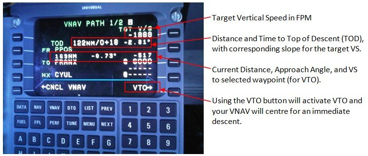
When you enter HNK-10 into the FMS, it does the above math for you, and advises when you are at the Top of Descent (TOD). It then repeats this process for all crossing altitudes you input into the VNAV system (such as a complex STAR). In these cases the FMS does a little extra math to determine the slope between the two points (it’s not necessarily always 3 degrees). The FMS VNAV page will show you the slope and vertical speed between each waypoint on the screen. The displayed Vertical Speeds (VS) are also helpful to let you know, if you started descent right now, what VS would be required. This is known as VTO, or Vertical To, the same way as DTO on a GPS means Direct To.
Let’s look some more at what VS is required to maintain the standard 3 degree slope. Again, there is a rule of thumb, and it is 5x your Groundspeed (GS). If we go back to our example of crossing HNK-10 from cruise, we first look at our FMS or MFD for the current groundspeed. Assuming no wind, let's say a regional airliner flies at a GS of 400 Knots. 5x400 = 2000 fpm. If we descend at 2000 fpm, the 3x distance calculation will be valid.
To better understand, check out the image at the end of this article.
As we get significant winds changing our groundspeed, the results for our VS calculation will change. This is where the VNAV function of the FMS makes life easier for us. We set the desired VS (normally 2000 fpm) and the VNAV function will accurately determine our revised TOD distance; and then try to maintain a VS as close to 2000 fpm as possible. Remember, you must be in LNAV first (instead of heading) so that the FMS has a starting point for the calculations.
This logic carries through the arrival phase where we slow to a GS of 240 knots... our target VS would be about 1200 fpm (5x240). Though we may not be in VNAV for all altitude step downs (eg on radar vectors), ATC expects an appropriate vertical speed, and rounding to 1000 fpm matches the 3 degree profile closely.
It also helps to know what VS is required to fly a 3 degree final approach slope. If we are flying the approach at 180 knots, we need a VS of approximately 1000 fpm (5x180) reducing to a VS of 600 fpm when we are flying at 120 knots (5x120). So, if we find ourselves high at the beginning of the approach, we may need a VS of 1500-2000 fpm to capture our vertical path from above (ILS or VNAV).
VNAV is a great tool to make our arrival and approach more accurate; but the understanding of the fundamentals behind it should not be forgotten. That way, when ATC says “turn right direct CRANK, cross 10NM north of CRANK at 7000 feet" you can ballpark a number and maintain your Situational Awareness. You can start the aircraft down quickly in an approximate VS, then program the FMS VNAV to get an exact solution. If you happen to have the point already in the FMS, you could also look at the VTO VS for a starting point. However, if you rely solely on the FMS VNAV, by the time you get it set up, you may find you need 3000 fpm to make the restriction which probably won’t work if you’re also trying to slow for 250 knots through 10,000’. Like any other technology, FMS VNAV is a tool. We shouldn’t use tools blindly; we must always know what they are doing – so that we remain in control.